You are using an outdated browser. Please
upgrade your browser to improve your experience.
Coordinates
Coordinates
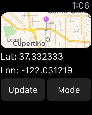
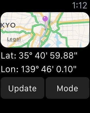
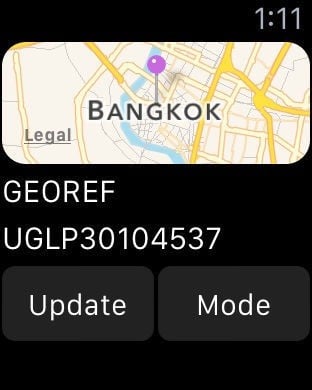
Coordinates is a powerful and user-friendly tool for anyone working with geographic locations — from travelers and surveyors to engineers and GIS professionals. Instantly view, convert, and manage coordinates in a wide range of global formats and datums, all within a clean and intuitive interface. Whether in the field or at the desk, Coordinates is your all-in-one solution for precise location work. # User-friendly Design Your current location is displayed at the intersection of two grey lines, with clear latitude and longitude readouts. You can manually set the location using map taps, coordinate input, or place search. Intuitive buttons give quick access to measurement tools, map layers, location bookmarking, shape drawing, and annotation — all from a clean, compact interface.# Various Coordinate FormatsSupports formats like UTM, MGRS, Georef, and more alongside Longitude/Latitude.# Batch Converter Quickly convert multiple coordinates or files in one streamlined action.# Rich Object Details Add notes, photos, and media to any saved object — pins, shapes, or measurements — to keep your data organized and context-rich. Easily share your saved content across devices using backup and export tools.# Datum ConversionTransform coordinates using EPSG, ESRI, and IAU2000 references. Supports X/Y, geodetic, and projected systems.# PROJ.4 Calculator Convert coordinates between systems using the PROJ.4 library, with support for datum shifting and custom projections.# Navigation & TrackingReal-time bearing and distance updates are provided with a large coordinate readout, ideal for on-the-field usage.# Speedometer Track your current speed in real time.# Unit ConverterConvert 40+ unit types (distance, pressure, radiation, etc.)# Signal BoardSend big bold messages on-screen# Elevation SupportAltitude data is available for land areas.# Import / Export- .gpx .geojson .kml file supported# Distance, Bearing & AreaMark points or draw lines to measure distance, bearings, and area.# Offline Map TilesDownload tiles for offline use. Pick a city or define your own area.# Custom Map Tile SelectorChoose from Apple Maps, OSM, or add your own tile server with {z}/{x}/{y} format.# Supported Input / Output #Latitude and Longitude DD/DM/DMSStandard UTMNATO UTMMGRS / USNGGeorefQTH Locator / Maidenhead (WGS84) World Mercator(WGS84) Web MercatorGeohashwhat3wordsGlobal Area Reference System (GARS) Ordnance Survey National Grid [BNG]OSGB36ISO 6709Natural Area CodeIrish Grid Reference / CoordinatesPlus Code (Open Location Code)MapcodeDutch GridECEFIndian Kalianpur 1975Open PostcodeGeohash-36Guatemala GTMRT90SWEREF99Indian 1975QND95 / Qatar National GridIRENET95 / Irish Transverse MercatorKOSOVAREF01 HD 72 / EOVKertau (RSO) / RSO MalayaTimbalai 1948 / RSO BorneoEST97 Estonian 1997LKS92 / Latvia TMNZGD49NZGD2000CH1903/+GGRS87ETRS89-extended / LAEA EuropeNTF (Paris) / Lambert zone IIFrench DFCI GridARINC 424FMSARC1950Pulkovo 1942 / SK42PZ-90H3PlacekeyGDM2000JGD2011KUDAMS/KTMWorld Magnetic Model / WMM 2015/WMM 2015v2 Search by namePhoto metadataProj.4 formatsStreet Address# Subscriptions #“Coordinates – GPS Converter” including most of its features, is completely FREE to use. You can subscribe to this application to remove adsPrice may vary by location. Payment for subscriptions will be charged to your iTunes Account at confirmation of purchase Subscription automatically renews unless auto-renew is turned off at least 24-hours before the end of the current period. Subscriptions may be managed by going to your iTunes Account Settings after purchase or by clicking the “Purchase / Manage Subscription. Auto-renewal may be turned off by going to Account Settings after purchase. Subscription cannot be cancelled during the active subscription periodPrivacy policy: https://mapnitude.com/privacy-policyTerms of use: https://mapnitude.com/terms-of-service
Features