You are using an outdated browser. Please
upgrade your browser to improve your experience.
Magic Earth Navigation & Maps

Magic Earth Navigation & Maps
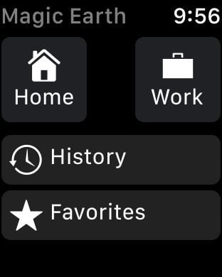
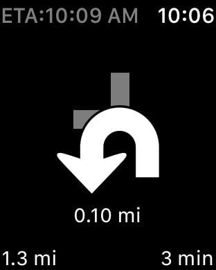
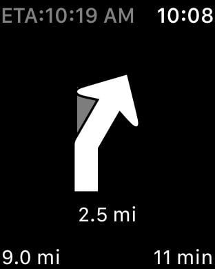
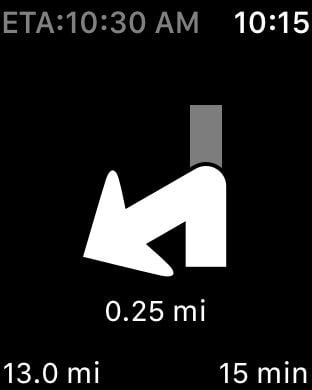
As we celebrate the 10-year anniversary of Magic Earth on the App Store in 2025, our commitment to privacy and innovation has never been stronger.For a small annual fee, you get a powerful platform that ensures your privacy. Magic Earth now requires a subscription, with a FREE 30-day trial available. Your support makes a big difference. Thank you for being part of the journey!Magic Earth uses OpenStreetMap data and a powerful search engine to offer you the optimal routes for driving, biking, hiking, and public transportation. Find the best route to your destination even without an internet connection.PRIVACY FIRST!• We do not track you. We do not profile you. We do not trade in your personal data; moreover, we do not have it.MAPS• Save big on mobile internet costs and navigate reliably with offline maps powered by OpenStreetMap. 233 countries and regions are ready to be downloaded. • Choose between 2D, 3D, and Satellite map views.• Get ready for travel and know every detail of your route like surface, difficulty, distance and elevation profile.• Learn more about the points of interest near you from Wikipedia articles.• Spot nearby parking places to easily park your car. • Stay up-to-date and enjoy regular free map updates.CARPLAY compatibility• Connect to Apple CarPlay and enjoy the ultimate navigation experience.NAVIGATION• Find the fastest or the shortest route to your destination when you travel by car, bike, on foot or with public transport. • Plan your route with multiple waypoints.• Stay safe with the free Head-up Display (HUD) feature which projects the most important navigation info onto the windshield of your car.• Know in advance which lane to take with precise turn-by-turn navigation and lane assistance.• Get notified about speed cameras and stay up to date with current speed limits. TRAFFIC INFO• Get real-time traffic info, updated every minute.• Discover alternative routes that avoid traffic jams and save you time on the road.PUBLIC TRANSPORT• Get around town quickly and easily. Choose from public transit routes that combine all transportation modes: bus / metro / subway / light rail / train / ferry • Get walking directions, transfer times, departure times, number of stops. And when available, the cost. • Find wheelchair or bike-friendly public transportation.WEATHER• View current temperature and local weather forecasts for your favorite locations.• See what weather conditions to expect in the next hours and view the forecast for the next 14 days.APPLE WATCH• Take a quick glance at your Apple Watch to get directions, distance, speed and workout details in real-time-right on your wrist.Notes:* Some features are not available in all countries.* Some features require internet connection.Your free trial will be automatically renewed to a paid subscription if you don't cancel it at least 24 hours before the end of the current period. The payment will be charged through your Apple ID account. Subscriptions automatically renew unless they are cancelled at least 24 hours prior to the end of the current period. You can manage or cancel your subscriptions in Settings after purchase.Privacy Policyhttps://www.magicearth.com/privacy/ Disclaimerhttps://www.magicearth.com/disclaimer/Terms of Usehttps://www.apple.com/legal/internet-services/itunes/https://www.apple.com/legal/internet-services/itunes/dev/stdeula/
Features